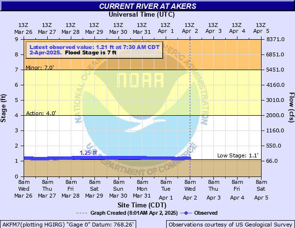
Loading map...
{"format":"leaflet","minzoom":false,"maxzoom":false,"limit":50,"offset":0,"link":"all","sort":[""],"order":[],"headers":"show","mainlabel":"","intro":"","outro":"","searchlabel":"... further results","default":"","import-annotation":false,"width":"auto","height":"500px","centre":false,"title":"","label":"","icon":"","lines":[],"polygons":[],"circles":[],"rectangles":[],"copycoords":false,"static":false,"zoom":false,"defzoom":14,"layers":["OpenStreetMap"],"image layers":[],"overlays":[],"resizable":false,"fullscreen":true,"scrollwheelzoom":true,"cluster":false,"clustermaxzoom":20,"clusterzoomonclick":true,"clustermaxradius":80,"clusterspiderfy":true,"geojson":{"type":"FeatureCollection","features":[{"type":"Feature","geometry":{"coordinates":[[-91.552055,37.375559],[-91.551325,37.37578],[-91.549995,37.375887],[-91.548745,37.375802],[-91.547323,37.375878],[-91.546106,37.376117],[-91.54477,37.375286],[-91.543831,37.374348],[-91.542844,37.373939],[-91.542292,37.373014],[-91.541889,37.372506],[-91.541283,37.369953],[-91.541777,37.368674],[-91.542292,37.367804],[-91.543257,37.366525],[-91.543429,37.365536],[-91.543901,37.364188],[-91.543772,37.36296],[-91.543279,37.362108],[-91.54212,37.360812],[-91.540618,37.359652],[-91.539288,37.359038],[-91.537549,37.358782],[-91.534932,37.358799],[-91.531498,37.358594],[-91.528451,37.359498],[-91.527915,37.359635],[-91.526392,37.35914],[-91.524589,37.358475],[-91.523838,37.357844],[-91.523023,37.357554],[-91.522229,37.357844],[-91.521306,37.35827],[-91.52019,37.35868],[-91.519568,37.359532],[-91.519654,37.360385],[-91.518474,37.361698],[-91.518152,37.362022],[-91.517315,37.362329],[-91.516156,37.362568],[-91.515148,37.362449],[-91.514525,37.361988],[-91.513903,37.36117],[-91.513495,37.360522],[-91.512465,37.359856],[-91.511564,37.358935],[-91.510084,37.357827],[-91.509848,37.356957],[-91.50914,37.356599],[-91.508067,37.356582],[-91.507702,37.356855],[-91.506178,37.356582],[-91.505084,37.356394],[-91.504011,37.355985],[-91.50399,37.355524],[-91.503196,37.355268],[-91.502316,37.355337],[-91.5012,37.356241],[-91.499999,37.357707],[-91.499333,37.358321],[-91.499162,37.35943],[-91.498303,37.360999],[-91.497424,37.361971],[-91.496608,37.362739],[-91.495793,37.363063],[-91.494098,37.363131],[-91.492832,37.362773],[-91.491287,37.362022],[-91.489999,37.36146],[-91.48869,37.36076],[-91.488004,37.359856],[-91.487253,37.358441],[-91.486952,37.356803],[-91.48663,37.355524],[-91.486266,37.354433],[-91.485643,37.353273],[-91.485364,37.352164],[-91.485665,37.350936],[-91.485429,37.349793],[-91.485021,37.348718],[-91.484098,37.348002],[-91.483347,37.347183],[-91.481824,37.346501],[-91.480601,37.346143],[-91.479421,37.345477],[-91.478906,37.345017],[-91.478369,37.344147],[-91.477575,37.343481],[-91.477017,37.34268],[-91.476674,37.342048],[-91.475987,37.341776],[-91.474378,37.3421],[-91.473219,37.342321],[-91.472619,37.342731],[-91.472297,37.343396],[-91.471331,37.344113],[-91.470301,37.344624],[-91.4694,37.345221],[-91.468391,37.345665],[-91.467297,37.345767],[-91.466267,37.345716],[-91.465752,37.345034],[-91.464894,37.344215],[-91.464036,37.34326],[-91.464207,37.342509],[-91.464787,37.341247],[-91.465881,37.339967],[-91.466503,37.339404],[-91.467361,37.339182],[-91.468134,37.338944],[-91.468627,37.338636],[-91.468542,37.337852],[-91.468155,37.336726],[-91.467597,37.336163],[-91.466954,37.335719],[-91.467168,37.335446],[-91.468306,37.334405],[-91.4694,37.333842],[-91.470494,37.33345],[-91.472039,37.333006],[-91.472876,37.332768],[-91.47382,37.332887],[-91.47543,37.333706],[-91.475923,37.334286]],"type":"LineString"},"properties":{"_umap_options":{"color":"Gold"},"title":"Akers Ferry to Pulltite"},"id":"tdBDq"}]},"clicktarget":"","showtitle":true,"hidenamespace":true,"template":"","userparam":"","activeicon":"","pagelabel":false,"ajaxcoordproperty":"","ajaxquery":"","locations":[{"text":"\u003Cb\u003E\u003Ca href=\"/wiki/Akers_Ferry\" title=\"Akers Ferry\"\u003EAkers Ferry\u003C/a\u003E\u003C/b\u003E","title":"Akers Ferry","link":"","lat":37.375574941661,"lon":-91.551974126839,"icon":"https://mywikis-wiki-media.s3.us-central-1.wasabisys.com/ozarkapedia/Marker-blue-12x12.png"},{"text":"\u003Cb\u003E\u003Ca href=\"/wiki/Cave_Spring_(Current_River)\" title=\"Cave Spring (Current River)\"\u003ECave Spring (Current River)\u003C/a\u003E\u003C/b\u003E","title":"Cave Spring (Current River)","link":"","lat":37.363417750481,"lon":-91.495915615021,"icon":"https://mywikis-wiki-media.s3.us-central-1.wasabisys.com/ozarkapedia/Marker-black-12x12.png"},{"text":"\u003Cb\u003E\u003Ca href=\"/wiki/Pulltite_Campground\" title=\"Pulltite Campground\"\u003EPulltite Campground\u003C/a\u003E\u003C/b\u003E","title":"Pulltite Campground","link":"","lat":37.334132967634,"lon":-91.475981734768,"icon":"https://mywikis-wiki-media.s3.us-central-1.wasabisys.com/ozarkapedia/Marker-blue-12x12.png"}],"GeoJsonSource":"Akers Ferry to Pulltite","GeoJsonRevisionId":604,"imageLayers":[]}