Cedar Grove to Akers Ferry
From Ozarkapedia
Jump to navigation
Jump to search
Loading map...
{"format":"leaflet","minzoom":false,"maxzoom":false,"limit":50,"offset":0,"link":"all","sort":[""],"order":[],"headers":"show","mainlabel":"","intro":"","outro":"","searchlabel":"... further results","default":"","import-annotation":false,"width":"auto","height":"500px","centre":false,"title":"","label":"","icon":"","lines":[],"polygons":[],"circles":[],"rectangles":[],"copycoords":false,"static":false,"zoom":false,"defzoom":14,"layers":["OpenStreetMap"],"image layers":[],"overlays":[],"resizable":false,"fullscreen":true,"scrollwheelzoom":true,"cluster":false,"clustermaxzoom":20,"clusterzoomonclick":true,"clustermaxradius":80,"clusterspiderfy":true,"geojson":{"type":"FeatureCollection","features":[{"type":"Feature","geometry":{"coordinates":[[-91.607952,37.422275],[-91.607459,37.422356],[-91.606858,37.422586],[-91.606756,37.422722],[-91.606214,37.422594],[-91.605688,37.422441],[-91.605259,37.422134],[-91.60497,37.42181],[-91.604664,37.421474],[-91.604068,37.421158],[-91.603612,37.420877],[-91.603328,37.420553],[-91.60299,37.420379],[-91.602765,37.420161],[-91.602636,37.419569],[-91.602867,37.419109],[-91.603189,37.418564],[-91.603392,37.418257],[-91.603956,37.41792],[-91.604524,37.417558],[-91.605114,37.416911],[-91.605592,37.41651],[-91.605849,37.416105],[-91.606117,37.415726],[-91.606439,37.414853],[-91.606407,37.41455],[-91.606246,37.414137],[-91.606064,37.413894],[-91.605737,37.413758],[-91.605184,37.41317],[-91.604347,37.412573],[-91.603553,37.412249],[-91.602459,37.411891],[-91.600356,37.411193],[-91.599154,37.411005],[-91.597674,37.41075],[-91.596279,37.41063],[-91.595592,37.410443],[-91.594884,37.410392],[-91.593897,37.410528],[-91.592889,37.411022],[-91.592009,37.411482],[-91.59128,37.411653],[-91.590035,37.412011],[-91.589541,37.412232],[-91.588812,37.412454],[-91.587868,37.412727],[-91.587439,37.413016],[-91.586988,37.413323],[-91.586752,37.413562],[-91.586001,37.413102],[-91.5854,37.412386],[-91.584756,37.411397],[-91.58452,37.410477],[-91.584799,37.410102],[-91.584778,37.409028],[-91.584821,37.40729],[-91.585207,37.40642],[-91.585379,37.405756],[-91.585851,37.405125],[-91.586881,37.404153],[-91.587975,37.403148],[-91.588876,37.403011],[-91.589692,37.403011],[-91.59055,37.402943],[-91.590958,37.402875],[-91.59188,37.402006],[-91.592331,37.401477],[-91.592352,37.400369],[-91.592224,37.399738],[-91.591773,37.399398],[-91.591644,37.398647],[-91.591151,37.397931],[-91.590807,37.397318],[-91.5904,37.396892],[-91.589863,37.396585],[-91.589305,37.396227],[-91.589348,37.396073],[-91.588769,37.396022],[-91.588104,37.396022],[-91.587095,37.39621],[-91.585979,37.396585],[-91.585486,37.39667],[-91.58452,37.396687],[-91.583555,37.39667],[-91.58289,37.396738],[-91.58201,37.397471],[-91.58143,37.398068],[-91.580701,37.398579],[-91.57995,37.398579],[-91.579199,37.398153],[-91.57877,37.397659],[-91.577847,37.397096],[-91.576924,37.396721],[-91.575809,37.396312],[-91.575122,37.396022],[-91.574607,37.395357],[-91.574392,37.394352],[-91.574693,37.393704],[-91.575036,37.393039],[-91.574907,37.392221],[-91.574564,37.391232],[-91.574264,37.390311],[-91.574221,37.389595],[-91.574392,37.388845],[-91.574564,37.388402],[-91.57495,37.388197],[-91.575122,37.387549],[-91.575036,37.387072],[-91.574435,37.386731],[-91.574006,37.386185],[-91.573749,37.385537],[-91.573319,37.385196],[-91.572161,37.385128],[-91.571217,37.385231],[-91.570358,37.385981],[-91.570315,37.386833],[-91.570101,37.387822],[-91.569543,37.388402],[-91.568534,37.388555],[-91.567376,37.388487],[-91.566625,37.388265],[-91.565702,37.387771],[-91.565101,37.387123],[-91.564908,37.385742],[-91.564479,37.385111],[-91.563942,37.3846],[-91.563706,37.383986],[-91.563084,37.383662],[-91.562376,37.382997],[-91.562076,37.382503],[-91.562076,37.381684],[-91.562483,37.380661],[-91.56287,37.380354],[-91.563385,37.38015],[-91.563771,37.379638],[-91.564457,37.378837],[-91.564887,37.378172],[-91.565444,37.377575],[-91.565402,37.376859],[-91.564522,37.375904],[-91.563449,37.375426],[-91.56199,37.375171],[-91.561217,37.374881],[-91.560681,37.374625],[-91.560123,37.37425],[-91.558878,37.374062],[-91.55817,37.373806],[-91.557612,37.373465],[-91.556818,37.373397],[-91.556067,37.373789],[-91.554801,37.374335],[-91.552076,37.375563]],"type":"LineString"},"properties":{"_umap_options":{"color":"Gold"},"title":"Cedar Grove to Akers Ferry"},"id":"W8eek"}]},"clicktarget":"","showtitle":true,"hidenamespace":true,"template":"","userparam":"","activeicon":"","pagelabel":false,"ajaxcoordproperty":"","ajaxquery":"","locations":[{"text":"\u003Cb\u003E\u003Ca href=\"/wiki/Akers_Ferry\" title=\"Akers Ferry\"\u003EAkers Ferry\u003C/a\u003E\u003C/b\u003E","title":"Akers Ferry","link":"","lat":37.375574941661,"lon":-91.551974126839,"icon":"https://mywikis-wiki-media.s3.us-central-1.wasabisys.com/ozarkapedia/Marker-blue-12x12.png"},{"text":"\u003Cb\u003E\u003Ca href=\"/wiki/Cedar_Grove\" title=\"Cedar Grove\"\u003ECedar Grove\u003C/a\u003E\u003C/b\u003E","title":"Cedar Grove","link":"","lat":37.422102871783,"lon":-91.608128915068,"icon":"https://mywikis-wiki-media.s3.us-central-1.wasabisys.com/ozarkapedia/Marker-blue-12x12.png"},{"text":"\u003Cb\u003E\u003Ca href=\"/wiki/Welch_Spring\" title=\"Welch Spring\"\u003EWelch Spring\u003C/a\u003E\u003C/b\u003E","title":"Welch Spring","link":"","lat":37.393972,"lon":-91.574467,"icon":"https://mywikis-wiki-media.s3.us-central-1.wasabisys.com/ozarkapedia/Marker-black-12x12.png"}],"GeoJsonSource":"Cedar Grove to Akers Ferry","GeoJsonRevisionId":603,"imageLayers":[]}
| MM | Place | Notes |
|---|---|---|
| 7.7 | ◢ Cedar Grove | NPS, Gravel access. ⛺ |
| 15.3 | ◢ Akers Ferry | NPS, Gravel access. ⛺🚽🗑 |
Accesses: ◢ Concrete, ◢ Gravel, ◢ Slab, ◢ Rough
Facilities: ⛺ Camp, 🚽 Toilet, 🗑 Trash Receptacle
Highlights & Hazards: ☗ Cave, ⛘ Bluff,🌢 Spring, ⚠ Hazard, ➥ Confluence
Description[edit | edit source]
Highlights & Hazards[edit | edit source]
Welch Spring & Hospital Ruins
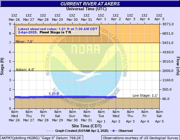
Gauge[edit | edit source]
The nearest relevant gauge is downstream, at Akers.