Loading map...
{"format":"leaflet","minzoom":false,"maxzoom":false,"limit":50,"offset":0,"link":"all","sort":[""],"order":[],"headers":"show","mainlabel":"","intro":"","outro":"","searchlabel":"... further results","default":"","import-annotation":false,"width":"auto","height":"500px","centre":false,"title":"","label":"","icon":"","lines":[],"polygons":[],"circles":[],"rectangles":[],"copycoords":false,"static":false,"zoom":false,"defzoom":14,"layers":["OpenStreetMap"],"image layers":[],"overlays":[],"resizable":false,"fullscreen":true,"scrollwheelzoom":true,"cluster":false,"clustermaxzoom":20,"clusterzoomonclick":true,"clustermaxradius":80,"clusterspiderfy":true,"geojson":{"type":"FeatureCollection","features":[{"type":"Feature","geometry":{"coordinates":[[-91.35385,37.153172],[-91.353008,37.152587],[-91.351705,37.151663],[-91.351254,37.151047],[-91.35046,37.150346],[-91.349988,37.150244],[-91.349602,37.150278],[-91.34928,37.150346],[-91.348743,37.150671],[-91.346169,37.151355],[-91.344345,37.151458],[-91.343701,37.151714],[-91.342328,37.153202],[-91.340954,37.155272],[-91.340536,37.155806],[-91.340182,37.155866],[-91.340176,37.156336],[-91.340348,37.156926],[-91.340606,37.157384],[-91.340852,37.158072],[-91.340697,37.158653],[-91.340606,37.159414],[-91.341094,37.161522],[-91.340547,37.163036],[-91.34001,37.163634],[-91.340053,37.16425],[-91.340439,37.164831],[-91.340203,37.165276],[-91.34016,37.166148],[-91.339753,37.166866],[-91.338959,37.167327],[-91.338358,37.167498],[-91.338165,37.167498],[-91.337607,37.16808],[-91.337435,37.169003],[-91.336684,37.170166],[-91.335976,37.170439],[-91.335053,37.170371],[-91.334088,37.169995],[-91.333745,37.169841],[-91.333058,37.169208],[-91.332543,37.168268],[-91.332221,37.167601],[-91.33177,37.165618],[-91.330826,37.164985],[-91.328359,37.16425],[-91.327779,37.163908],[-91.327071,37.16401],[-91.325891,37.16519],[-91.32544,37.166387],[-91.324432,37.166558],[-91.323037,37.166558],[-91.321964,37.16731],[-91.321321,37.168713],[-91.320419,37.169978],[-91.319733,37.170679],[-91.318359,37.171226],[-91.317523,37.171192],[-91.316299,37.171038],[-91.315742,37.170799],[-91.315269,37.170371],[-91.314776,37.170115],[-91.314197,37.169875],[-91.313531,37.169824],[-91.313124,37.169909],[-91.312695,37.170149],[-91.311815,37.171175],[-91.310849,37.172166],[-91.31042,37.172936],[-91.309111,37.174133],[-91.307781,37.174765],[-91.307008,37.175039],[-91.30585,37.17509],[-91.304369,37.175415],[-91.303854,37.175381],[-91.302953,37.174987],[-91.302481,37.17468],[-91.30233,37.174406],[-91.302137,37.173962],[-91.301794,37.173739],[-91.301107,37.173244],[-91.299691,37.172269],[-91.298575,37.171636],[-91.298296,37.171465],[-91.297417,37.171465],[-91.296773,37.171739],[-91.296473,37.17232],[-91.296473,37.172765],[-91.295099,37.17244],[-91.294713,37.172183],[-91.294541,37.172183],[-91.293941,37.171756],[-91.293061,37.17191],[-91.292653,37.172081],[-91.292331,37.172372],[-91.292074,37.172867],[-91.292074,37.173192],[-91.292267,37.173329],[-91.292353,37.17362],[-91.29261,37.173893],[-91.292696,37.174577],[-91.292868,37.175073],[-91.293232,37.17562],[-91.293941,37.176834],[-91.294305,37.17774],[-91.294305,37.178253],[-91.294649,37.179313],[-91.294456,37.180236],[-91.294155,37.180527],[-91.29364,37.18133],[-91.293533,37.181912],[-91.293404,37.182339],[-91.292782,37.182903],[-91.292524,37.183296],[-91.291602,37.184049],[-91.291173,37.184237],[-91.290464,37.184339],[-91.289735,37.184185],[-91.289306,37.184031],[-91.289027,37.183707],[-91.288748,37.183655],[-91.288447,37.183655],[-91.286967,37.183142],[-91.286023,37.182219],[-91.283512,37.181467],[-91.283104,37.181518],[-91.282761,37.181587],[-91.281989,37.182322],[-91.279478,37.183724],[-91.278942,37.184237],[-91.278341,37.185091],[-91.277783,37.185587],[-91.277547,37.186254],[-91.277525,37.186886],[-91.27759,37.187382],[-91.27774,37.187758],[-91.277933,37.188049],[-91.278427,37.188698],[-91.27847,37.189245],[-91.278319,37.189844],[-91.278019,37.190254],[-91.277504,37.190015],[-91.276925,37.190032],[-91.276474,37.190408],[-91.275444,37.190596],[-91.275015,37.190835]],"type":"LineString"},"properties":{"name":"Eminence to Two Rivers"},"id":"UzODU"}]},"clicktarget":"","showtitle":true,"hidenamespace":true,"template":"","userparam":"","activeicon":"","pagelabel":false,"ajaxcoordproperty":"","ajaxquery":"","locations":[{"text":"\u003Cb\u003E\u003Ca href=\"/wiki/Hole_in_the_Wall_Bluff\" title=\"Hole in the Wall Bluff\"\u003EHole in the Wall Bluff\u003C/a\u003E\u003C/b\u003E","title":"Hole in the Wall Bluff","link":"","lat":37.171303,"lon":-91.336502,"icon":"https://mywikis-wiki-media.s3.us-central-1.wasabisys.com/ozarkapedia/Marker-grey-12x12.png"},{"text":"\u003Cb\u003E\u003Ca href=\"/wiki/Joshua_T._Chilton_Memorial_Landing\" title=\"Joshua T. Chilton Memorial Landing\"\u003EJoshua T. Chilton Memorial Landing\u003C/a\u003E\u003C/b\u003E","title":"Joshua T. Chilton Memorial Landing","link":"","lat":37.153,"lon":-91.354,"icon":"https://mywikis-wiki-media.s3.us-central-1.wasabisys.com/ozarkapedia/Marker-blue-12x12.png"},{"text":"\u003Cb\u003E\u003Ca href=\"/wiki/Shawnee_Creek_Campground\" title=\"Shawnee Creek Campground\"\u003EShawnee Creek Campground\u003C/a\u003E\u003C/b\u003E","title":"Shawnee Creek Campground","link":"","lat":37.172431,"lon":-91.3,"icon":"https://mywikis-wiki-media.s3.us-central-1.wasabisys.com/ozarkapedia/Marker-blue-12x12.png"},{"text":"\u003Cb\u003E\u003Ca href=\"/wiki/Two_Rivers_Campground\" title=\"Two Rivers Campground\"\u003ETwo Rivers Campground\u003C/a\u003E\u003C/b\u003E","title":"Two Rivers Campground","link":"","lat":37.190767,"lon":-91.274307,"icon":"https://mywikis-wiki-media.s3.us-central-1.wasabisys.com/ozarkapedia/Marker-blue-12x12.png"}],"GeoJsonSource":"Eminence to Two Rivers","GeoJsonRevisionId":292,"imageLayers":[]}
The lowest section of Jacks Fork, ending at Two Rivers.
The first two miles of this float are inside the "Eminence Gap", part of the river not inside the Ozark National Scenic Riverways. This can mean more boats or different priorities from law enforcement. The State of Missouri grants the public access to boat, paddle, and wade the river up to the normal high water mark, which is marked by where permanent vegetation like bushes and trees start to grow. Avoid areas marked with purple paint, flags, or tape - this is a Private Property No Tresspassing convention for Missouri.
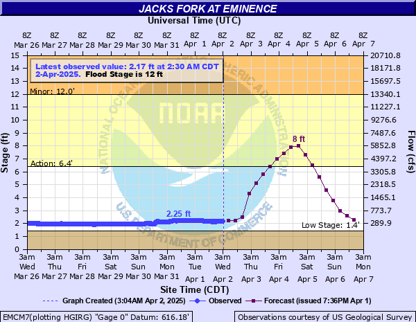
The lower Jacks Fork, from Alley to Two Rivers, is floatable year round thanks to the springs that feed it. You can get an idea of the current levels using the gauge at Eminence.